�Ŵ���ɳȺ������ʷ��ͼ(4)
ʱ��: 2011-09-05 15:25 ��Դ����ѧ��ʷ�� qing ���:
[ͼ�г����α�ע��Shoal of Pracel, �������ϵļ���С��ע��Ϊthe Triangle(?)����]
��һʱ��Ҳ���ռ�������ָ���������Դ�������������ϵ���ϸ����ͼ��ʱ�ڣ���Щ��ͼ����Oriental Pilot����East India Pilot֮�����档���нܳ��ĸ���������̰���John Seller����������English Pilot�Ķ������ֱ�John Thornton, Mount and Page, Sayer and Bennett, Laurie and Whittle�Լ�John Norie��ɲ����档Alexandra Dalrymple (1737-1808)�����˴����Ķ����ǵ�ͼ���ƵĹ��������������ɴ�����һЩ�Ƚϲ�Ϊ��֪����ͼ�һ��Ƶ���һ����ĵ�ͼ����Aaron ArrowsmithҲΪ������������ף���������1806 Pilot from England to Canton������
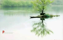
�����ͼ����ҵҲ��19���ͼ������٣�������William Darton�����Ķ����ǣ�Figure 4����

Figure 4 The East India Islands, William Darton, c. 1812
[��߳�����ע��ΪParacels����Amphitrite, Dry Lime ? Shoal����]
�����John Tallis and Company��1851������The Illustrated Atlas of the WorldҲֵ��һ�ᣬ�Ȿ��ͼ���е�ÿ�ŵ�ͼ�϶�����С������ط���ֲ�װ���ر�����Plate 6����

Plate 6 Malay Archipelago or East India Islands, J&F. Tallis, from the Illustrated Atlas of the World, 1851
[��ͼ��ע�� North Sh(oa)l, Paracels, Amphitrite Is, Crescent, Discovery Shoal, Bombay Shoal, Macclesfield Bank, Scarborough Shoal��������������Ⱥ��ע�Ѿ������Ϻ��ִ�������һ��]
[����������Щ��ͼ�⣬�Ȿ���л������˼�����ͼ��]
����ͳ���У���


�ȵ�����


��ʷ����
����>>
-

����˻ʺ� -------------------------------------------------...
-
��ʷ (1329.1-1329.8)��λ����λ8�����ڣ���������Ԫ���ڳ��ӡ�...
-

������(����)���� ��λ52�� ����������������һ���ܣ������ܣ���...
-

��� (701762��)�����壬��̫�ף���������ʿ���Ĵ������ˣ��ƴ�...
-

(һ) ˴�ۣ���Ҧ����˵Ŀ��˫ͫ��ȡ�����ػ������������ϣ��ʳ�...